
More project photos (2)
The problem
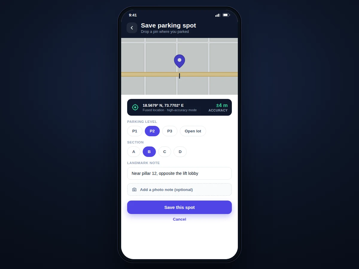
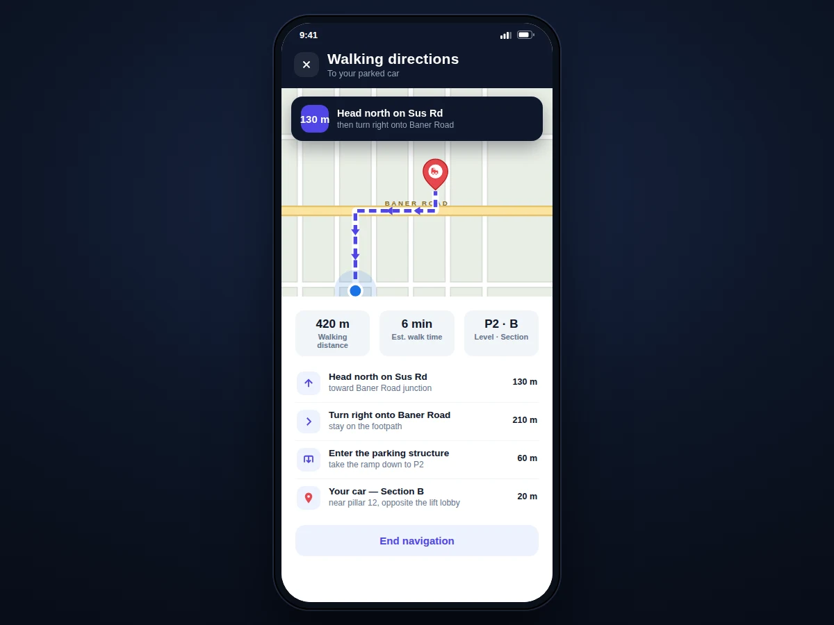
Every driver knows the walk of shame around a mall parking lot, pressing the key fob and listening for a beep. Phone-based "find my car" features exist, but they stop at a raw GPS pin — useless on level P2 of a concrete basement where GPS does not reach, and silent about the one detail that actually matters indoors: which pillar you parked next to. This project builds a complete Android app around that gap. One tap captures a high-accuracy GPS fix through the FusedLocationProviderClient; the app then prompts for the structured context GPS cannot provide — parking level, section, a landmark note ("near pillar 12, opposite the lift") and an optional photo. When it is time to leave, the Maps SDK draws a walking route from the user's live position back to the saved spot with a turn-by-turn list, while a parking timer tracks the session and fires a reminder before the meter expires. Arrival is detected with a GeofencingClient fence around the spot, which stops the timer and archives the session to history.
The user parks and taps once to save the spot. Later they follow walking directions back to the car.
Follow the working sequence
How it works
- The user taps "Save this spot" — the app requests a single high-accuracy location fix from the FusedLocationProviderClient (balanced against battery by requesting one update, not continuous tracking).
- The coordinates, accuracy radius (± metres) and timestamp are written to the Room database, and the user adds level, section, a landmark note and an optional photo.
- A GeofencingClient geofence of 100 m radius (configurable) is registered around the saved coordinates to detect the return walk.
- The parking timer starts counting; WorkManager schedules an exact reminder notification ahead of the user-entered meter expiry, surviving device reboots.
- On "Walking directions", the app fetches the user's live position and asks the Maps SDK to draw the walking route polyline to the saved spot, rendering the turn-by-turn step list with per-leg distances.
- When the geofence fires on arrival — or the user taps "Found my car" — the timer stops, the session is archived to history, and the geofence is removed.
Tech stack:
- Kotlin
- Maps SDK for Android
- FusedLocationProviderClient (Play Services Location)
- GeofencingClient (Play Services Location)
- Room persistence library
- WorkManager
- CameraX
- Material Design 3
| Parameter | Value |
|---|---|
| Platform | Android 8.0 (API level 26) and above (design target) |
| Language | Kotlin |
| Location provider | FusedLocationProviderClient, high-accuracy single fix (Play Services) |
| Map and routing | Maps SDK for Android (internet required for tiles and routes) |
| Local storage | Room database, on-device, survives app restarts |
| Typical outdoor GPS accuracy | Approximately ±3–10 m (expected, environment-dependent) |
| Geofence radius | 100 m (configurable in settings) |
| Meter reminder | Via WorkManager; fires 5, 15 or 30 min before expiry (user-selectable) |
| Demo build size | Approximately 25–40 MB APK (expected) |
| Background battery use | No continuous tracking; location requested only on save and during navigation (design choice) |
Project features
- [One-tap GPS spot saving] A single tap requests a high-accuracy fix from the FusedLocationProviderClient and stores the latitude, longitude, accuracy radius and timestamp — the core interaction of the whole app.
- [Level, section and landmark notes] Structured fields for parking level (P1/P2/P3/open lot), section and a free-text landmark note capture exactly what GPS cannot, which is what makes the app work in basement parking.
- [Photo note] An optional photo of the surroundings or pillar number can be attached to the saved spot using CameraX, so visual memory backs up the coordinates.
- [Walking directions back to the car] The Maps SDK for Android renders the live map, draws the walking route polyline from the user's current position to the saved spot, and lists turn-by-turn steps with per-leg distances.
- [Parking timer with meter-expiry reminders] Each session tracks elapsed parking time, and WorkManager schedules a notification a configurable 5/15/30 minutes before the meter expiry the user enters.
- [Geofence arrival detection] A GeofencingClient fence (100 m radius, configurable) around the saved spot detects when the user walks back to the car, stops the timer and archives the session automatically.
- [Offline-first spot history] Every saved spot and session persists in a Room database on the device, so the parking record survives app restarts and works without connectivity; past sessions are browsable by date.
What is included
- Complete Kotlin source code (Android Studio project)
- Room database schema and data-layer code
- Working demo build of the app for testing on a real device
- Setup and build instructions (SDK versions, API key configuration for the Maps SDK)
- Project report PDF (background, Android location APIs, methodology, screens, limitations)
- PPT presentation for final review
- Viva Q&A preparation document (FusedLocationProviderClient vs GPS provider, geofencing limits, Room vs SharedPreferences, WorkManager guarantees)
Limitations & prerequisites
- GPS fixes are unreliable or unavailable in underground and basement parking — the level/section/landmark note and photo are the designed fallback there, and the page states this honestly.
- Map tiles and walking routes require an internet connection; only the saved spot record itself works fully offline.
- Outdoor GPS accuracy is approximately ±3–10 m and degrades near tall buildings, so the pin marks the general bay area, not the exact slot.
- Geofence entry detection is batched by the OS and can lag by a few minutes; "Found my car" manual stop is provided for immediacy.
- The app is phone-side only — there is no OBD dongle or vehicle-hardware integration, so it cannot track a car that someone else drives away.
- Continuous background location tracking is deliberately not implemented, to keep battery use low.
Frequently Asked Questions
Is this project suitable for a final-year project?
Yes — for Computer Engineering, IT and mobile-application programs. It demonstrates real Android platform APIs (location, geofencing, background work, local persistence, maps), a complete user flow from problem to solution, and honest handling of a genuine hardware limitation in its viva documentation.
Which Android APIs does it actually use?
FusedLocationProviderClient for the GPS fix, GeofencingClient for arrival detection, the Maps SDK for Android for map rendering and walking routes, Room for offline spot storage, WorkManager for meter-expiry reminders, and CameraX for the optional photo note — all standard, documented platform APIs.
Does it work in basement parking where GPS fails?
The GPS pin will be weak or missing there, which is exactly why the app collects level, section, landmark note and photo — those fields are the primary "find my car" mechanism indoors, and the report explains this design decision for the viva.
Does it need internet all the time?
The app is offline-first: saving a spot works without any connection, since coordinates go straight to the on-device Room database. Internet is needed only for map tiles and drawing the walking route; the parking timer, expiry reminders and session history never need connectivity.
Can it save the spot automatically without a tap?
Not in the base build — automatic detection (activity-recognition driving detection, or Bluetooth disconnect from the car stereo) is listed as future scope, because reliable auto-detection needs careful testing across devices and is kept out of the base project deliberately.
What will I receive with the project?
You receive the complete Kotlin source as an Android Studio project, the Room database schema, a working demo build to test on a real device, and setup instructions covering SDK versions and Maps SDK key configuration — plus the project report PDF, a review PPT and a viva Q&A document. Suitable for B.E./B.Tech final-year projects in Computer Engineering, Information Technology and Mobile Application Development.
Components & software requirements
- Kotlin
- Maps SDK for Android
- FusedLocationProviderClient (Play Services Location)
- GeofencingClient (Play Services Location)
- Room persistence library
- WorkManager
- CameraX
- Material Design 3
Delivery information
Built-to-order project. Delivery timeline is shared after order confirmation based on current queue.
Support terms
Complete documentation, setup guide, and viva preparation included. Support for setup and explanation provided.
Download free synopsis (PDF)
Enter your name and WhatsApp number — the synopsis PDF downloads immediately. We may send occasional project updates on WhatsApp; no spam.