
More project photos (2)
The problem
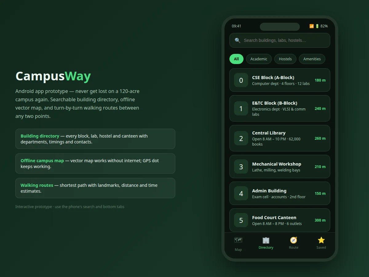
First-year students routinely get lost on large campuses: the exam cell is "in the admin building, second floor" — but which building is the admin building, and which of its three entrances? Public map apps draw the campus boundary but know nothing of its blocks, labs, hostels and canteens, and they need internet that newcomers may not have. CampusWay is designed for exactly one campus and knows it completely: the directory answers "what is where" (every building with departments, timings, contacts and walking distance), the offline vector map answers "where am I" with a live GPS dot and no data needed, and the router answers "how do I walk there" with landmark instructions that work better on foot than street names ("turn left at the fountain circle"). Saved places and recent searches make repeat trips one tap.
How it works
- The building dataset (name, category, description, relative distance) loads into the directory; text search and category chips filter it live.
- The SVG vector map renders the campus plan — blocks, roads, hostels, sports ground — with each building tappable.
- Tapping a building highlights it and opens its detail card with distance, category and open-now status, plus a Directions button.
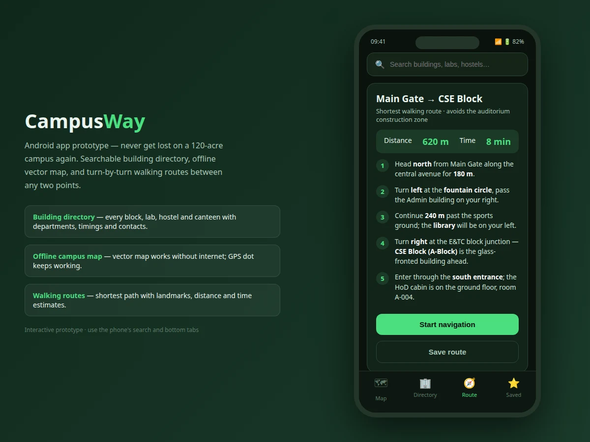
- The route screen presents the curated shortest path as numbered landmark steps with segment distances, total distance and walking time.
- Saved places persist the user's starred buildings; recent searches list the last lookups for one-tap reopening.
- Bottom-tab navigation switches the four screens; the prototype mirrors the native app's information architecture one to one.
Tech stack:
- Interactive web prototype: HTML5, CSS3, vanilla JavaScript (phone-frame UI)
- Inline SVG vector campus map (offline-capable)
- Native build path: Kotlin, MapLibre/Google Maps SDK, fused location provider
- Local persistence path: Room database; map pack: bundled vector tiles
- No backend — on-device map and data
| Parameter | Value |
|---|---|
| Prototype screens | 4 (Map, Directory, Route, Saved) (as shipped) |
| Buildings in directory | 11 with categories and details (as shipped) |
| Directory categories | Academic, Hostels, Amenities (3 filters) (as shipped) |
| Example route steps | 5 landmark-based walking steps (as shipped) |
| Example route | Main Gate → CSE Block, 620 m, ~8 min (demo data) |
| Map dependency | None — inline SVG renders offline (as shipped) |
| Prototype size | Single HTML file, approximately 19 KB (expected) |
| Native target | Android 9+ (design target for the native build) |
Project features
- [Building directory] Eleven campus buildings with category, description, relative distance — text search plus Academic/Hostels/Amenities filter chips.
- [Offline vector map] An SVG campus plan that renders with zero connectivity, with a pulsing "you are here" marker and tappable buildings.
- [Tap-for-details] Tapping a map building opens its directory card (distance, category, open status) with a Directions action.
- [Walking routes] A complete example route (Main Gate → CSE Block) with five landmark-based steps, distance and time estimates.
- [Saved places & recents] Starred locations and recent searches for one-tap repeat navigation.
- [Phone-frame prototype] All four screens (Map, Directory, Route, Saved) demonstrated interactively in a mobile UI with bottom-tab navigation.
- [Native build path documented] The report maps each screen to Android APIs (location services, vector tiles, local database).
What is included
- Fully interactive web prototype of all four app screens
- Screen-by-screen native API mapping document (location, tiles, database)
- Project report PDF (background, mobile-mapping concepts, methodology, screenshots)
- PPT presentation for final review
- Viva Q&A preparation document (offline maps, routing UX, location APIs)
- User guide for demonstrating the prototype
Limitations & prerequisites
- The deliverable is an interactive prototype demonstrating every screen and flow; the native Kotlin build is documented as the build path, not shipped as an APK.
- Distances and the example route are curated demo data for the fictional campus plan, not surveyed measurements.
- Live GPS positioning needs a device and location permission; the prototype shows a representative fixed position.
- Turn-by-turn voice guidance and indoor floor maps are listed as future scope.
Frequently Asked Questions
Is this a real installable app?
The deliverable is a fully interactive prototype demonstrating every screen and flow with realistic campus data, plus a documented native build path mapping each screen to Android APIs. It is presented honestly as a prototype.
Why not just use Google Maps?
Public maps lack building-level campus data (which block is the exam cell in?) and need internet. CampusWay ships the campus's own directory and an offline map — the knowledge generic maps don't have.
How do the walking directions work?
Routes are built on a campus walkway graph; instructions reference landmarks ("turn left at the fountain circle") because landmarks beat street names for pedestrians.
Does the map really work offline?
The prototype's map is inline SVG — zero network needed. The native design bundles the vector tile pack the same way.
What should I be able to explain in the viva?
Why offline vector tiles beat raster for this use case, how the directory search/filter works, how landmark routing is generated, and which Android location APIs the native build uses — all in the Q&A document.
Is this project suitable for a final-year project?
Yes — for Computer Science, IT and mobile-development programs. It solves a genuine campus problem with directory search, offline mapping and route UX. Suitable for B.E./B.Tech final-year projects in Computer Science, IT and Web/Mobile Development.
Components & software requirements
- Interactive web prototype: HTML5, CSS3, vanilla JavaScript (phone-frame UI)
- Inline SVG vector campus map (offline-capable)
- Native build path: Kotlin, MapLibre/Google Maps SDK, fused location provider
- Local persistence path: Room database; map pack: bundled vector tiles
- No backend — on-device map and data
Delivery information
Built-to-order project. Delivery timeline is shared after order confirmation based on current queue.
Support terms
Complete documentation, setup guide, and viva preparation included. Support for setup and explanation provided.