
More project photos (2)

The problem
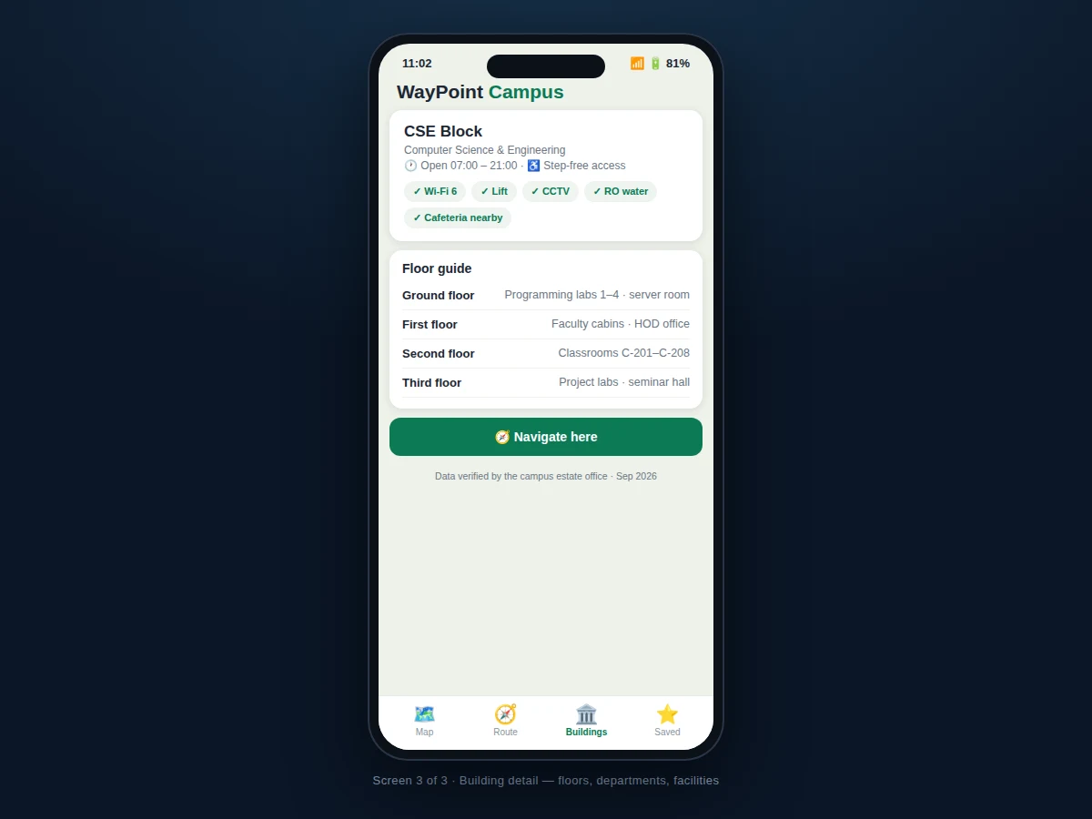
Every semester, thousands of first-year students, visiting parents and guest lecturers get lost on large campuses: the "CSE Block" is three identical-looking buildings away, the auditorium entrance faces the wrong road, and the campus map PDF — if one exists — is a blurry scan from 2019. Signboards help only if you can find one. WayPoint Campus replaces the PDF with a living map: a clean vector rendering of roads, buildings, grounds and gardens that works fully offline, a search box that finds "Seminar Hall 2" faster than asking around, and walking routes drawn from the user's live position with turn-by-turn steps ("turn right at the Library junction, 120 m"). The building detail screens do what signboards can't — floor guides naming what's on each floor, facilities (lift, Wi-Fi, RO water), open hours and step-free access notes. The estate office's data stays editable in one JSON dataset, so the map never goes stale the way the PDF did. The build is Kotlin with an on-device map renderer and the fused location provider — no map SDK keys, no data connection required.
How it works
- The campus is surveyed once into a dataset: building footprints, pedestrian paths, road centrelines and points of interest.
- The app renders this as a vector map fully offline — pan and zoom with no tiles to download.
- The user searches for a building or taps its pin; the detail sheet shows departments, floors and facilities.
- Tapping "Navigate here" runs the on-device router over the pedestrian path graph from the user's live position.
- The route draws as a highlighted path with turn-by-turn steps naming distances and landmarks ("past the sports ground").
- The step-free toggle re-routes to avoid stairs where the dataset marks accessible alternatives.
- The estate office updates the single JSON dataset (new building, renamed hall) and ships it with the next app update.
Tech stack:
- Kotlin (Android app language)
- Android Studio (build & layout tooling)
- On-device vector map rendering (custom Canvas/SVG pipeline)
- Fused Location Provider (GPS positioning)
- Dijkstra/A* routing over the pedestrian path graph
- Room · SQLite (cached dataset + saved places)
- Material Design 3 components
- MVVM architecture
- Git version control
| Parameter | Value |
|---|---|
| Platform | Android 8.0 (API 26) and above (design target) |
| Map data | Bundled vector dataset, fully offline |
| Positioning | GPS + network fused, ~5–10 m typical |
| Routing | On-device shortest-path over pedestrian graph |
| Dataset format | Versioned JSON (buildings, paths, POIs) |
| Step-free mode | Accessibility-aware re-routing |
| Saved places | On-device favourites |
| Build | Single APK via Android Studio |
Project features
- [Offline vector campus map] Roads, buildings, grounds and gardens rendered on-device from a bundled dataset — zero internet needed.
- [Building search] Search across buildings, labs and halls with instant filtering; results jump straight to the map pin.
- [Turn-by-turn walking routes] From the user's live position to any building: highlighted path with steps, distances and landmarks.
- [Live "you are here" position] Blue-dot positioning with recenter; route start defaults to the current location.
- [Building detail screens] Departments, floor-by-floor guide, facilities, open hours and step-free access notes per building.
- [Step-free route option] An accessible routing preference that avoids stairs and steep paths.
- [Nearby buildings sheet] Quick list of the closest buildings for "what's around me" discovery.
- [Editable campus dataset] Buildings, paths and metadata live in one versioned JSON file the estate office can update.
What is included
- Complete Kotlin Android app source code
- Campus map dataset schema + sample 42-acre campus dataset
- Offline vector map renderer
- On-device pedestrian router with turn-by-turn steps
- Building detail screens (floors, facilities, hours)
- Project report PDF (problem, map data model, routing algorithm, testing)
- PPT presentation for final review
- Viva Q&A preparation document (vector rendering, Dijkstra/A*, fused location, offline design)
Limitations & prerequisites
- The map covers the campus dataset only — it is not a general city navigator and has no road-traffic data.
- Indoor (floor-level) positioning is not included; the router guides to building entrances.
- Positioning accuracy is GPS-grade (~5–10 m); the app does not use beacons or Wi-Fi RTT.
- The dataset is bundled per release; live over-the-air map updates are a listed extension.
- Routing quality depends on the path graph being surveyed completely — missing paths mean missing routes.
Frequently Asked Questions
Does it need the internet?
No. The vector map, the routing graph and the building data all ship inside the app; only the live blue-dot position uses the phone's GPS.
How is the campus data created?
A one-time survey is encoded as a versioned JSON dataset (building footprints, paths, POIs); the sample 42-acre campus dataset is included and the schema is documented for reuse.
Which routing algorithm is used?
Dijkstra/A* shortest path over the pedestrian path graph, with edge weights from path length; the step-free mode penalizes stair edges.
How accurate is the walking time?
Time is estimated from path length at a standard walking speed; the route card shows both distance and minutes.
Can the college update the map?
Yes — buildings, names and paths live in one JSON file; edits ship with the next app update, and OTA dataset updates are future scope.
Is this project suitable for a final-year project?
Yes — for Computer Science, IT and mobile development programs. It demonstrates vector map rendering, graph routing algorithms, GPS integration and offline-first mobile architecture. Suitable for B.E./B.Tech final-year projects in Computer Science, IT and mobile application development.
Components & software requirements
- Kotlin (Android app language)
- Android Studio (build & layout tooling)
- On-device vector map rendering (custom Canvas/SVG pipeline)
- Fused Location Provider (GPS positioning)
- Dijkstra/A* routing over the pedestrian path graph
- Room · SQLite (cached dataset + saved places)
- Material Design 3 components
- MVVM architecture
- Git version control
Delivery information
Built-to-order project. Delivery timeline is shared after order confirmation based on current queue.
Support terms
Complete documentation, setup guide, and viva preparation included. Support for setup and explanation provided.