
More project photos (3)
The problem
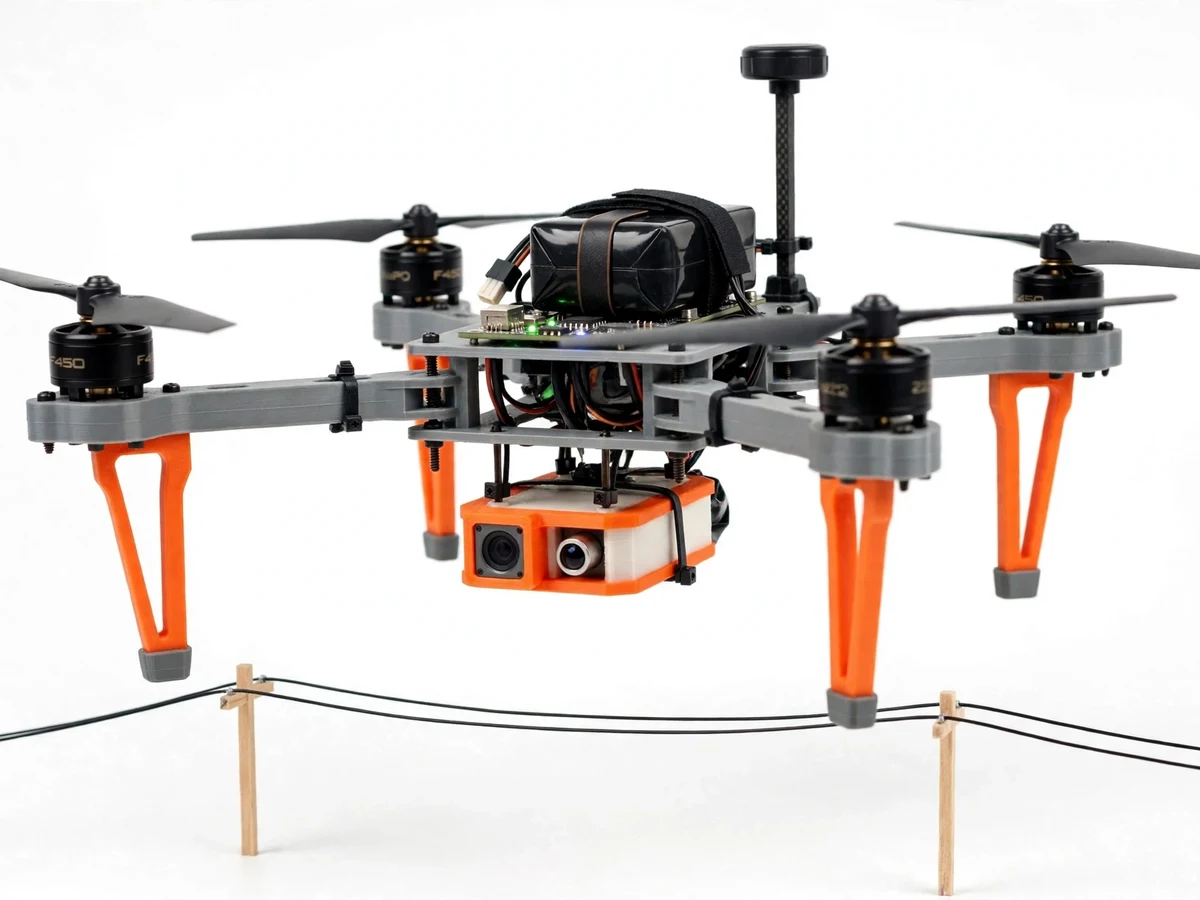
Power lines, solar farms and factory roofs fail quietly: a loose connector heats up a few degrees at a time, and by the time anyone notices, the fault has become an outage or a fire. Professional inspection drones solve this by flying thermal cameras over the asset — DJI launched the Matrice 5T on 5 November 2026 for exactly this work, with a reported 1280×1024 thermal imager, a LiDAR that spots thin power lines up to a reported 32 m, mmWave radar that keeps working in fog and dust, and a reported 59-minute flight time. This project rebuilds that idea honestly at student scale: an F450 quadcopter with a Pixhawk flight controller, a TF-Luna LiDAR for terrain following, a 24 GHz mmWave radar module for obstacle alerts, and an MLX90640 thermal camera that finds hot spots on a mock power line, all watched from an ESP32 ground station.
| This student build | DJI Matrice 5T (reported figures) | Plain camera drone | |
|---|---|---|---|
| Thermal imaging | MLX90640 · 32×24 pixels · ±1.5°C (Datasheet value) | 1280×1024 thermal imager (reported) | No thermal camera |
| LiDAR ranging | TF-Luna · 0.2–8 m · ±6 cm (Datasheet value) | Spots power lines up to 32 m (reported) | None |
| Obstacle sensing in fog or dust | HLK-LD2410 24 GHz radar · up to 6 m (Datasheet value) | mmWave radar, works in fog, dust, rain, snow (reported) | Camera only, blind in fog |
| Flight time | Approximately 12–15 min (design target) | Up to 59 min (reported) | Approximately 12–15 min (design target) |
| Zoom | Fixed ESP32-CAM, no zoom | 11× optical, 176× hybrid (reported) | Fixed camera, no zoom |
| Video link | Wi-Fi · approximately 100 m (design target) | O4 Enterprise, dual 4G, approximately 40 km (reported) | Wi-Fi · approximately 100 m (design target) |
| Laser ranging | None | Up to 3,000 m (reported) | None |
| Weather sealing | None — fair weather only | IP55 (reported) | None |
The operator arms the drone and starts the inspection pass over the mock power line.
Follow the working sequence
How it works
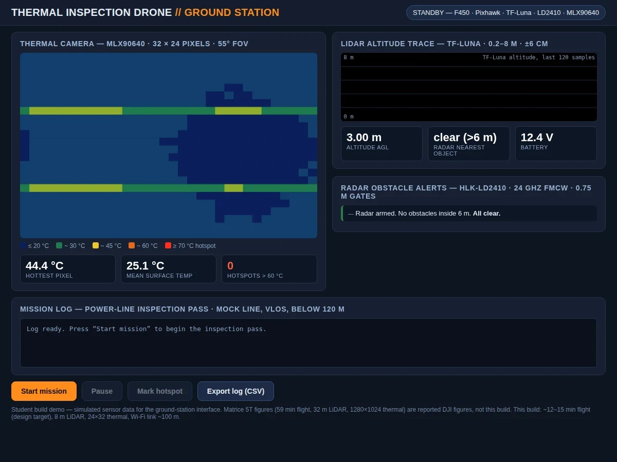
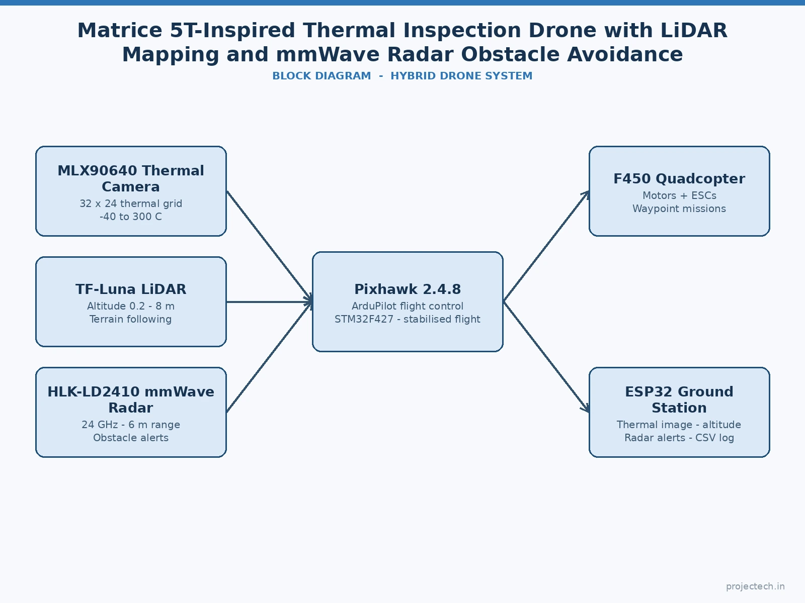
The mission starts on the ground station, where the operator arms the drone and starts the inspection pass over a mock power line strung between two poles. The Pixhawk lifts the F450 to its 3 m hold height and flies a slow visual-line-of-sight pattern along the line while the TF-Luna LiDAR measures the ground below many times a second, feeding the altitude hold. The MLX90640 thermal camera scans the conductors for hot spots while the ESP32-CAM streams the visible view, and the HLK-LD2410 radar watches the air ahead in 0.75 m gates, calling a hold if anything comes inside 6 m. Every reading lands on the ESP32 ground station — thermal grid, altitude trace, radar alerts and mission log — and the operator marks hot spots and exports the log as a CSV file at the end of the pass.
- The builder assembles the F450 frame with four 2212 920KV motors, 30A ESCs, 8045 propellers and a 3S 5000 mAh LiPo, mounts the Pixhawk 2.4.8 with its GPS mast, and fits the orange sensor pod underneath with the TF-Luna LiDAR, HLK-LD2410 radar and MLX90640 thermal camera.
- The builder loads ArduPilot Copter onto the Pixhawk with Mission Planner, calibrates the accelerometer, compass and radio, sets the failsafe to return-to-home on signal loss, and checks the motors spin in the correct directions with no propellers fitted.
- The builder powers the sensor pod, checks the TF-Luna reads a steady distance to the floor, the radar reports clear beyond 6 m, and the MLX90640 shows a live thermal image with a warm hand clearly visible as a hot cluster.
- The builder sets up the mock inspection line — two poles with a wire strung between them — and plans a short visual-line-of-sight pass along it at a 3 m hold height, below 120 m, in a permitted area with no people underneath.
- The operator starts the mission from the ESP32 ground station: the drone lifts off, the Pixhawk holds altitude from the LiDAR reading, and the thermal camera scans the wire while the visible camera streams alongside it.
- During the pass the ground station logs the thermal grid, the LiDAR altitude trace and every radar alert; if the radar reports an object inside 6 m the operator holds position, and any pixel cluster above 60°C is marked as a hot spot.
- The operator lands, exports the mission log as a CSV file, and checks the marked hot spots against the visible-camera frames to confirm each one is a real warm connection and not a sun-heated wire.
Tech stack:
- Pixhawk 2.4.8 flight controller · ArduPilot Copter firmware
- F450 quadcopter frame · 2212 920KV BLDC motors · 30A ESCs
- Benewake TF-Luna LiDAR · single-point ToF ranging
- HLK-LD2410 mmWave radar · 24 GHz FMCW presence detection
- Melexis MLX90640 thermal camera · 32×24 pixel array
- ESP32-CAM · OV2640 visible-light camera feed
- ESP32 ground station · thermal overlay and mission log
- 3S 5000 mAh LiPo battery · 12–15 min design-target flight
| Parameter | Value |
|---|---|
| Build type | Hybrid quadcopter plus ESP32 ground-station software (design target) |
| Frame | F450 quadcopter frame · 450 mm motor-to-motor diagonal (design target) |
| Motors | 4× DYS 2212 920KV BLDC · 56.8 g each · max continuous current 17.2 A · approximately 600 g thrust per motor at 11.1 V with 8045 prop (vendor test data) |
| ESCs | 4× 30 A brushless ESCs · 2–4S input · 30 A continuous current (vendor rating) |
| Flight controller | Pixhawk 2.4.8 · STM32F427 Cortex-M4 at 168 MHz · 256 KB RAM · 2 MB flash · ArduPilot Copter firmware (vendor specification) |
| LiDAR | Benewake TF-Luna · 0.2–8 m range · ±6 cm accuracy at 0.2–3 m · ±2% at 3–8 m · 1 cm resolution · 2° FOV · 100 Hz default frame rate (Datasheet value) |
| Radar | HLK-LD2410 · 24–24.25 GHz FMCW · farthest sensing distance up to 6 m · 0.75 m distance resolution · ±60° detection angle · UART 256000 baud · 5 V supply (Datasheet value) |
| Thermal camera | Melexis MLX90640 · 32×24 pixels · 55°×35° FOV · −40 to 300°C object range · ±1.5°C typical accuracy · up to 64 Hz refresh (Datasheet value) |
| Visible camera | ESP32-CAM · OV2640 2 MP sensor · up to 1600×1200 stills · Wi-Fi 802.11 b/g/n 2.4 GHz (Datasheet value) |
| Battery and flight time | 3S 5000 mAh LiPo · 11.1 V nominal · flight time approximately 12–15 min (design target) |
| Link | Wi-Fi 2.4 GHz ground-station link · approximately 100 m line of sight (design target) |
| Trend reference | DJI Matrice 5T launched 5 November 2026 · reported figures only: 1280×1024 thermal imager · LiDAR spots power lines up to 32 m · mmWave radar works in fog, dust, rain, snow · 11× optical and 176× hybrid zoom · laser ranging to 3,000 m · up to 59 min flight · IP55 · approximately €8,600 · never claimed for this build |
| Builder note | A single-point LiDAR measures one distance, not a picture: terrain following works because the TF-Luna's 2° beam points straight down and the Pixhawk holds altitude off that one number, so the beam must stay clear of the landing legs and the sensor pod — mount it on the belly, not on an arm. The MLX90640's 768 pixels each read a temperature, so a hot spot is a cluster of warm pixels, not a shape — the dashboard flags any pixel above 60°C and the student confirms it against the visible camera before calling it a fault. The radar's 0.75 m gates are coarse on purpose: an alert inside 6 m means hold position and look, not swerve, because a quadcopter cannot dodge sideways off one range number. |
Project features
The build earns its place on a review table because three different sensors answer three different inspection questions at once. The MLX90640 thermal camera watches for heat: a loose connector on the mock power line shows up as a cluster of warm pixels long before it shows in visible light. The TF-Luna LiDAR answers the height question, measuring the ground below to the centimetre so the Pixhawk can hold a steady 3 m above the line instead of drifting. The HLK-LD2410 radar answers the safety question, warning of an obstacle inside 6 m even when fog or dust blinds the camera. Around those sensors sits the flight stack — a Pixhawk 2.4.8 running ArduPilot — and an ESP32 ground station that puts the thermal image, the LiDAR altitude trace, the radar alerts and the mission log on one screen with a CSV export.
- [Thermal hotspot detection] The MLX90640 reads a 32×24 grid of surface temperatures from −40 to 300°C with ±1.5°C typical accuracy (Datasheet value), and the dashboard flags any pixel cluster above 60°C as a hot spot on the conductor — implemented in the base build.
- [LiDAR terrain following] The TF-Luna measures the ground below from 0.2 to 8 m with ±6 cm accuracy at 0.2–3 m (Datasheet value), and the Pixhawk holds the drone at a steady altitude above the mock line instead of drifting with the barometer — implemented in the base build.
- [mmWave radar obstacle alerts] The HLK-LD2410 24 GHz FMCW radar watches the air ahead in 0.75 m distance gates out to 6 m (Datasheet value), and the ground station raises an alert and calls a hold when anything enters that range, even in fog or dust where the camera is blind — implemented in the base build.
- [Pixhawk and ArduPilot flight control] The Pixhawk 2.4.8 runs ArduPilot Copter on a 168 MHz STM32F427 with 256 KB RAM and 2 MB flash (vendor specification), giving stabilised flight, altitude hold, return-to-home failsafe and waypoint missions — implemented in the base build.
- [ESP32 ground-station dashboard] The dashboard shows the live thermal grid, the LiDAR altitude trace, the radar alert panel and the mission log on one screen, with a CSV export of the full log at the end of the pass — implemented in the base build.
- [Visible-light camera feed] The ESP32-CAM with its OV2640 2 MP sensor streams the visible view over Wi-Fi at up to 1600×1200 stills (Datasheet value), so every thermal hot spot can be checked against a normal photograph before it is reported — implemented in the base build.
- [Mission log with CSV export] Every second of the pass is logged — altitude, hottest pixel, mean temperature and radar distance — and the log exports as a CSV file the student can open in a spreadsheet and quote in the report — implemented in the base build.
- [Automatic hotspot return] Future scope only, not implemented: after the pass, the drone returns by itself to each marked hot spot and photographs it from closer in, listed as an extension rather than a claimed feature, since the base build marks hot spots by hand from the ground station.
What is included
- Complete F450 quadcopter fitted with four 2212 920KV motors, 30A ESCs, 8045 propellers, Pixhawk 2.4.8 flight controller with GPS, and a 3S 5000 mAh LiPo battery
- Sensor pod with TF-Luna LiDAR, HLK-LD2410 mmWave radar module, MLX90640 thermal camera and ESP32-CAM visible camera, wired and mounted under the frame
- ArduPilot Copter configuration with altitude hold, return-to-home failsafe and a waypoint mission for the mock-line inspection pass
- ESP32 ground-station dashboard (live thermal grid, LiDAR altitude trace, radar alert panel, mission log, CSV export)
- Setup and calibration guide (Pixhawk calibration, sensor checks, mock-line setup, DGCA flying rules, first-flight checklist)
- Project report PDF (Matrice 5T background with reported figures labelled as reported, sensor selection, flight control, demonstration results, honest measurement limits)
- PPT presentation for final review
- Viva Q&A preparation document (why thermal imaging finds faults, how single-point LiDAR holds altitude, why radar works in fog, why this build is not the Matrice 5T, flight-time and range limits)
Limitations & prerequisites
- Not the Matrice 5T: this is a student F450 build inspired only by the Matrice 5T's inspection idea; it shares no parts, performance or capability with DJI's drone and must never be presented as one.
- Flight time approximately 12–15 minutes as a design target, not the Matrice 5T's reported up to 59 minutes, because the 3S 5000 mAh battery and the sensor pod's weight limit the air time.
- LiDAR range 8 m, not 32 m: the TF-Luna is a single-point sensor that measures one distance straight down, so it cannot map a scene or spot a thin wire ahead the way the Matrice 5T's reported LiDAR does.
- Thermal resolution 32×24 pixels, not 1280×1024: the MLX90640 shows heat as a coarse grid, so a hot spot is a cluster of warm pixels and must be confirmed against the visible camera before it is called a fault.
- Radar is presence and range, not imaging: the HLK-LD2410 reports that something is inside a 0.75 m gate out to 6 m, but it cannot show what the object is or draw a picture of it.
- No zoom, no laser ranging, no weather sealing: the ESP32-CAM is a fixed camera, there is no 3,000 m laser ranger, and the build has no IP55 rating, so it flies in fair weather only.
- Wi-Fi link approximately 100 m, not 40 km: the ground station works over 2.4 GHz Wi-Fi in visual line of sight, and the drone must stay below 120 m and in sight at all times.
- Legal boundary: Indian DGCA rules apply — fly only in permitted areas, never over people, keep the drone in visual line of sight, and check the current Digital Sky registration requirement for this weight class before the first flight.
Frequently Asked Questions
Is this project suitable for a final-year project?
Yes, for IoT, Electronics and Electrical programmes, because it combines flight control, three different sensors, embedded firmware and a web dashboard into one testable loop, with a clear review thread around thermal inspection, LiDAR altitude holding and radar obstacle alerts.
Is this the DJI Matrice 5T?
No. The Matrice 5T is DJI's inspection drone launched on 5 November 2026, with a reported 1280×1024 thermal imager, reported 32 m LiDAR, reported mmWave radar and a reported 59-minute flight time, at a reported price around €8,600. This is a student F450 build with a 32×24 thermal camera, an 8 m LiDAR, a 6 m radar module and a 12–15 minute design-target flight.
How does the radar see through fog when the camera cannot?
The HLK-LD2410 sends out 24 GHz radio waves, which pass through fog, dust and light rain that scatter visible light, and listens for the reflection. It reports presence and distance in 0.75 m gates out to 6 m — it does not form an image, so the operator still needs the visible camera to identify what the radar found.
What is the flight time and range?
Approximately 12–15 minutes per battery as a design target, and the Wi-Fi ground-station link works to approximately 100 m in line of sight. The drone flies in visual line of sight below 120 m, and the 59-minute flight and 40 km link of the Matrice 5T are reported DJI figures, not claimed here.
Do I need a licence or permission to fly it?
Indian DGCA rules apply to this weight class: fly only in permitted areas, keep the drone in visual line of sight below 120 m, never fly over people, and check the current Digital Sky registration requirement before the first flight. The demonstration uses a short mock-line pass in an open permitted area.
What will I receive with the project?
The F450 quadcopter with Pixhawk flight controller and sensor pod, the ArduPilot configuration, the ESP32 ground-station dashboard with CSV export, the setup and calibration guide, the project report, the presentation and the viva Q&A document. A laptop or phone on the same Wi-Fi and a permitted flying area are needed, both covered in the setup guide.
Components & software requirements
- Pixhawk 2.4.8 flight controller · ArduPilot Copter firmware
- F450 quadcopter frame · 2212 920KV BLDC motors · 30A ESCs
- Benewake TF-Luna LiDAR · single-point ToF ranging
- HLK-LD2410 mmWave radar · 24 GHz FMCW presence detection
- Melexis MLX90640 thermal camera · 32×24 pixel array
- ESP32-CAM · OV2640 visible-light camera feed
- ESP32 ground station · thermal overlay and mission log
- 3S 5000 mAh LiPo battery · 12–15 min design-target flight
Delivery information
Built-to-order project. Delivery timeline is shared after order confirmation based on current queue.
Support terms
Complete documentation, setup guide, and viva preparation included. Support for setup and explanation provided.
Download free synopsis (PDF)
Enter your name and WhatsApp number — the synopsis PDF downloads immediately. We may send occasional project updates on WhatsApp; no spam.