
More project photos (2)
The problem
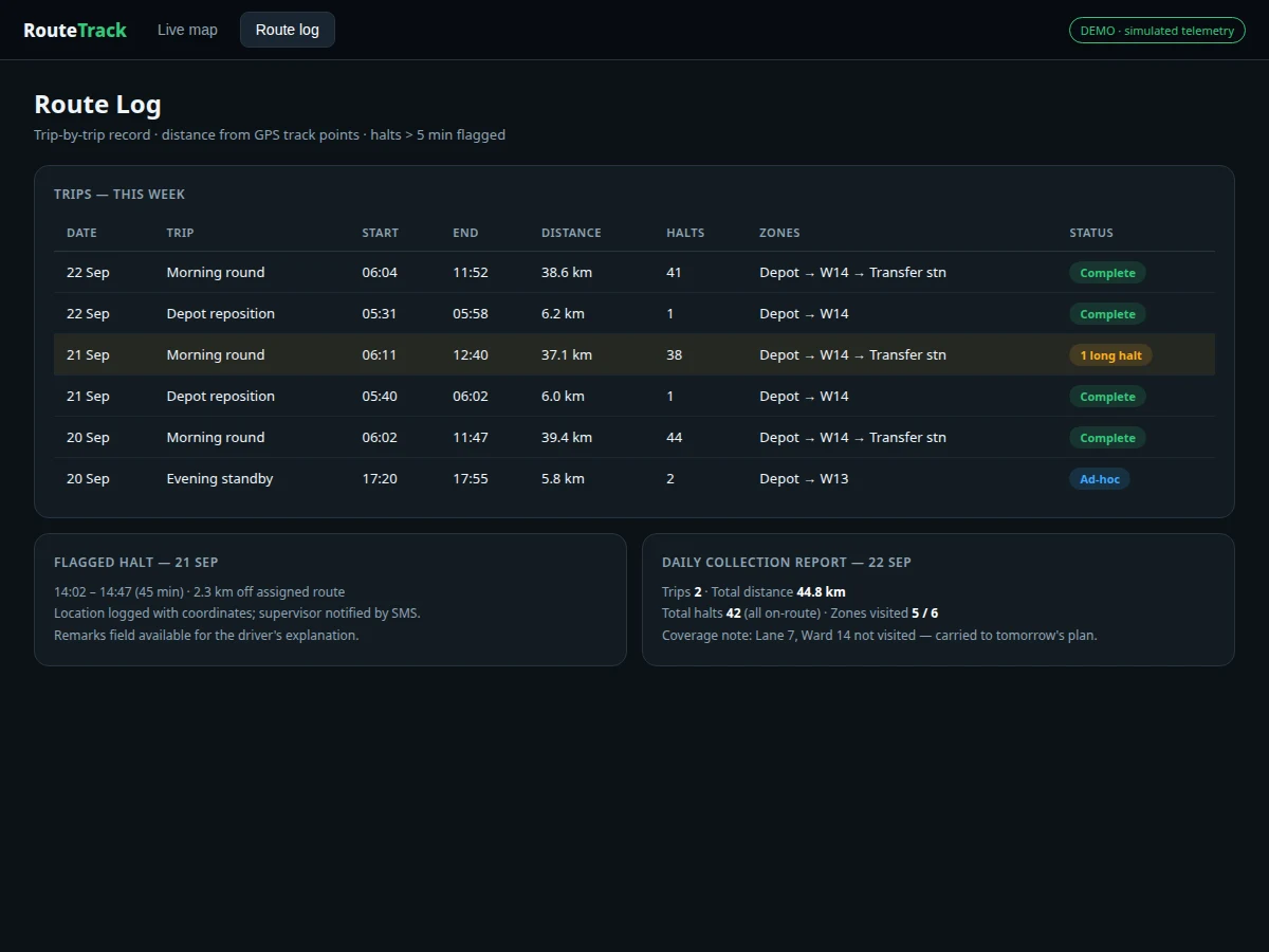
Municipal bodies and private waste contractors struggle to verify that garbage trucks actually cover their assigned routes: missed streets, skipped bins and unofficial detours are hard to prove after the fact. Paper logbooks are easy to falsify and commercial fleet trackers are priced for large fleets, not for a student project or a small contractor. The practical fix is a low-cost tracker built from commodity modules: GPS for position, GSM for upload, and a microcontroller that ties them together on vehicle power. This project builds exactly that — an ESP32-based tracker with a NEO-M8N GPS receiver and SIM800L GSM module in a rugged enclosure, drawing from the truck's 12 V supply through a buck converter, plus a web dashboard with live map, route playback, a trip-by-trip route log and zone entry/exit alerts. The route log is the heart of the build: every trip is stored with start/end times, distance computed from track points, halt detection and zone crossings, so the report and viva can discuss real fleet-management data rather than a blinking LED.
How it works
- The NEO-M8N GPS receiver acquires a satellite fix (typically ±2.5 m CEP per its datasheet) and streams NMEA position sentences to the ESP32.
- Every 10 seconds the ESP32 packages latitude, longitude, speed, heading and timestamp and sends it over the SIM800L's GPRS link to the server.
- If the network is unavailable, fixes are written to the ESP32's flash buffer and uploaded in chronological order when the link returns.
- The server stores each fix and groups them into trips: a trip starts when the truck leaves the depot zone and ends when it returns or stays parked beyond the idle threshold.
- Trip distance is computed by summing haversine distances between consecutive fixes; halts are detected where speed stays near zero beyond the threshold.
- Zone entry/exit is evaluated against the configured geofences (depot, transfer station, wards) and logged as events with timestamps.
- The dashboard renders the live map, route playback, route log table, halt markers and the daily collection report from this stored data.
Tech stack:
- ESP32 DevKit (Arduino-core firmware)
- NEO-M8N GPS module with magnetic-mount antenna (±2.5 m CEP typical, datasheet)
- SIM800L GSM/GPRS module with SIM slot and antenna
- 12 V to 5 V buck converter with reverse-polarity protection, rugged enclosure
- Backend: position ingest API + trip/zone processing
- Web dashboard: live map, route playback, route log, zone alerts, daily report
| Parameter | Value |
|---|---|
| Controller | ESP32 DevKit, Arduino-core firmware |
| Positioning | NEO-M8N GPS, ±2.5 m CEP typical (datasheet); cold-start fix typically under ~30 s with clear sky |
| Connectivity | SIM800L quad-band GSM/GPRS; external antenna |
| Update rate | Position upload every 10 s (configurable) |
| Power | Truck 12 V supply via buck converter; backup for brief outages |
| Offline buffer | Flash storage of fixes during network loss, uploaded in order on recovery |
| Trip metrics | Distance from haversine sum of fixes; halts flagged beyond 5-min threshold (configurable) |
| Zones | Depot, transfer station, ward geofences with entry/exit events + optional SMS |
| Dashboard | Live map, route playback with time slider, route log, daily collection report |
| Operating environment | Vehicle-mounted; GPS needs sky view — dense urban canyons degrade fixes |
Project features
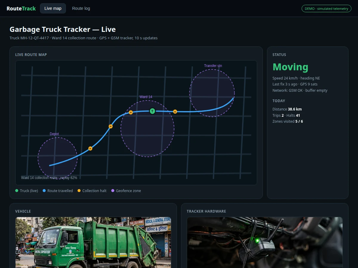
- [Live GPS tracking] Position updates every 10 seconds over GSM to the dashboard map, with the truck marker, heading and speed rendered in real time.
- [Route playback] Any recorded trip can be replayed on the map with a time slider — useful for verifying ward coverage street by street.
- [Route log] Every trip stored with start/end timestamps, distance from track points, duration, number of halts and zone crossings; searchable by date and vehicle.
- [Zone alerts] Geofenced depot, transfer station and ward zones raise entry/exit events on the dashboard and can trigger an SMS to the supervisor's number.
- [Halt detection] Stops longer than the configured threshold (default 5 minutes) are flagged on the route with location and duration — distinguishes collection halts from idle time.
- [Vehicle-powered operation] Runs on the truck's 12 V supply through a buck converter with reverse-polarity protection; a small backup keeps logging during brief power cuts.
- [Offline buffering] When the mobile network drops, positions are buffered on the ESP32 and uploaded in order when coverage returns — no gaps in the route log.
- [Daily collection report] Auto-generated summary per truck per day: trips, total distance, total halts, zone visits and coverage notes for the supervisor.
What is included
- Assembled GPS tracker unit (ESP32, NEO-M8N, SIM800L, buck converter, enclosure, antennas)
- Complete firmware (GPS parsing, GPRS upload, offline buffering, power management)
- Wiring and vehicle-installation guide (12 V tap, antenna placement, enclosure mounting)
- Backend server code (ingest API, trip grouping, zone evaluation, report generation)
- Web dashboard (live map, playback, route log, alerts, daily report)
- Project report PDF (background, hardware design, trip-processing logic, evaluation method)
- PPT presentation for final review
- Viva Q&A preparation document (GPS, NMEA, GSM/GPRS, geofencing, power design)
- Setup guide (SIM provisioning, server deploy, zone configuration, first trip)
Limitations & prerequisites
- GPS accuracy is typically ±2.5 m CEP in open sky per the module datasheet — dense urban canyons, tunnels and covered parking degrade or lose fixes, and the report states this openly.
- Position uploads need mobile network coverage; in dead zones the tracker buffers locally and uploads later, so live tracking pauses but the route log stays complete.
- Trip distance is computed from GPS fixes, not an odometer — it inherits GPS error and is an estimate, documented as such.
- The tracker needs the truck's 12 V supply while operating; wiring must be fused and the installation guide's safety notes followed.
- SIM800L is a 2G module — the buyer must confirm 2G/GPRS availability on their carrier in the deployment area; a 4G-module variant is a documented extension.
- One tracker per vehicle; multi-truck fleets need one unit each (the dashboard supports multiple vehicles).
Frequently Asked Questions
How accurate is the tracking?
The NEO-M8N datasheet quotes ±2.5 m CEP in open sky. In practice expect that in open areas and worse near tall buildings or under cover — the report documents these limits rather than claiming a single number.
What happens when the truck drives through a no-network area?
Fixes are buffered in the ESP32's flash and uploaded in order when coverage returns, so the route log stays complete even though live tracking pauses.
How is a trip defined?
A trip starts when the truck leaves the depot geofence and ends when it returns or remains parked beyond the idle threshold; distance is the haversine sum of its fixes.
Can the supervisor get alerts on their phone?
Yes — zone entry/exit events can trigger an SMS to a configured supervisor number, subject to the SIM having SMS credit and network coverage.
Does it work on any truck?
Any vehicle with a 12 V supply and a place to mount the GPS antenna with sky view. Installation needs a fused 12 V tap per the wiring guide.
Is this project suitable for a final-year project?
Yes — for Electronics, Electrical and IoT programs. It demonstrates GPS interfacing, GSM communication, embedded power design, backend data processing, geofencing and dashboard development, all strong viva material. Suitable for B.E./B.Tech final-year projects in Electronics, Electrical and IoT.
Components & software requirements
- ESP32 DevKit (Arduino-core firmware)
- NEO-M8N GPS module with magnetic-mount antenna (±2.5 m CEP typical, datasheet)
- SIM800L GSM/GPRS module with SIM slot and antenna
- 12 V to 5 V buck converter with reverse-polarity protection, rugged enclosure
- Backend: position ingest API + trip/zone processing
- Web dashboard: live map, route playback, route log, zone alerts, daily report
Delivery information
Built-to-order project. Delivery timeline is shared after order confirmation based on current queue.
Support terms
Complete documentation, setup guide, and viva preparation included. Support for setup and explanation provided.